In Shanxi Jinneng Group Coal Industry Co., Ltd, three drill holes, 4#, 6# and 9#, were drilled at 517m of 8206 lane for logging exploration, to pre-probe the distribution range of air mining area in front of the roadway headway.
2.Construction Arrangement
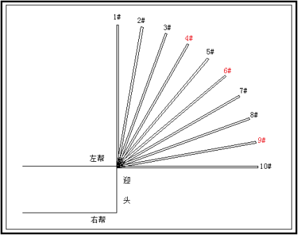
图1施工布置图
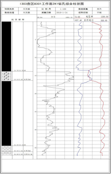
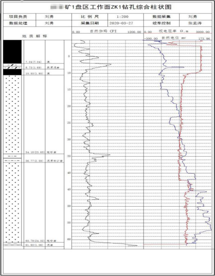
Figure 2 Drill hole composite histogram
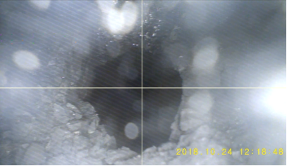
Figure 3 View screen intercept of 6# Drill Hole 23 in the air pocket
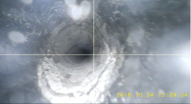
Fig. 4 Screenshot of view screen at 33m of 9# drill hole
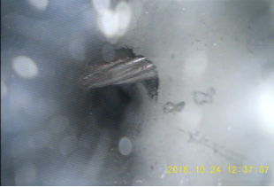
Fig. 5 Screenshot of view and 3D bar graph of other roadway support anchor cables in drill hole 9#.
①The 4# hole at 517m of 8206 roadway in this exploration, there is a layer of interbedded gangue in the middle 14.03m of the coal seam, and the lithology is charcoal mudstone, and the pseudo-thickness is 2.46m;
② The 6# hole at 517m of the 8206 roadway detected this time is a full coal hole, and the hollow area is found near 23m;
③ 9# holes at 517m of 8206 roadway in this detection, and the support anchor cable of the mining hollow area is found near 14m; 33m is the coal-rock intersection surface.
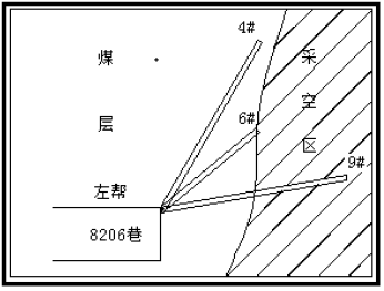
Figure 6 Map of consolidated results
The combined results indicate that there is an air extraction zone in the left direction in front of the headway at 517m in Lane 8206 (see the map of the combined results).
In a mine of Tong Coal Group, two water exploration and discharge drill holes at 17.8m before HS3.and 45.83m before HS3.were logged and pre-detected:
(1) Water outflow from the air-mined area of 4# coal seam;
(2) The distribution of rock layers at the top of 5# coal seam;
(3) The deviation of drilling trajectory.
2.Physical exploration results
|
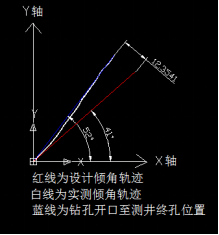
Figure 2 Drilling trajectory diagram
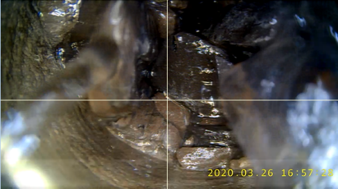
Fig. 3 Collapse of the air-mined area at the bottom of hole ZK1
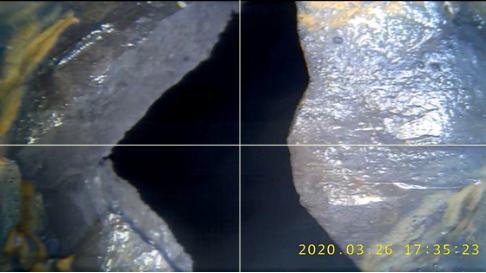
Fig. 4 Screenshot of video of ZK2 hole bottom extraction zone
(1) This time, there are two water exploration and discharge drill holes, both of which were drilled to the 4# coal seam, and the reason for water discharge from the drill holes is the accumulation of water in the 4# coal seam.
(2) Deviation of drill hole trajectories
Name of drill hole
Design inclination
Design orientation
Design depth
Measured depth
Deviation of measured inclination trajectory from design trajectory
Deviation of measured inclination trajectory from design orientation
ZK1
41°
44°
77m
62m
The measured inclination trajectory of the drill hole is along 52°, and the final hole position deviates from the designed final hole position by 12.5m.
The measured azimuth trajectory of the drill hole is along 46°, and the final hole position deviates from the designed final hole position by 4.1m.
ZK2
90°
45m
42m
The measured inclination trajectory of the drill hole is along 88°, and the final hole position deviates from the designed final hole position by 1.2m.
Table 1 Deviation between measured and designed trajectories of drill holes
(3) Distribution of rock strata in the top plate of No.5 coal seam
Lithology
Starting position of rock layer (m)
End position of rock layer (m)
Thickness of rock layer
(m)
Coal
0
3.6
3.6
Carbonaceous mudstone
3.6
5.19
1.59
Coal
5.19
7.04
1.85
Coarse sandstone
7.04
23.97
16.93
Muddy siltstone
23.97
24.87
0.9
Coarse sandstone
24.87
39.79
14.92
Muddy siltstone
39.79
41.48
1.69
Table 2 Distribution of lithology of the top plate of 5# coal seam


 Current position:
 Mining Video Imaging Logging Instrument