In order to ensure the safe production of coal mine, it is necessary to use the seismic profile imaging technology to detect the influence of trapped columns in the right gang of N3-9 belt chute of a coal mine of Lu'an Group. The geological task of this detection is to find out the influence range of trapped columns in the right gang of N3-9 belt chute.
2.Construction arrangement
Seismic profile imaging technology is used to detect the side gang of the roadway, and the site construction is as follows: the seismic source is chosen to be the hammer source, the hammer point is arranged on the side of the geophone, 3 geophones receive the data, and the hammer point is 2m away from the nearest one of the geophones, with a spacing of 2m between the channels, and a moving spacing of 2m, for a total of 133m. The construction layout is as follows.
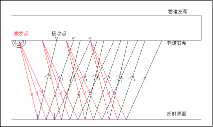
Construction layout of seismic profiling technology
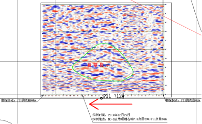
N3-9 belt trough right gang seismic profile imaging technology physical exploration interpretation results map
From the map of the results of the physical exploration interpretation of the right gang seismic profile of the N3-9 belt trench, it can be seen that there exists one waveform anomaly area within the detection range, and the locations are as follows:
Anomaly zone 1: 36m after point P11-32m in front of point P11 and 15-55m in depth.
According to the physical properties and experience of No.3 coal seam, the empirical wave speed of 1700m/s is used in this detection; combined with the field detection conditions, measured data and comprehensive analysis of geological data: the anomaly area is caused by the influence of the development zone of trapped column.


 Current position:
 Mining Video Imaging Logging Instrument